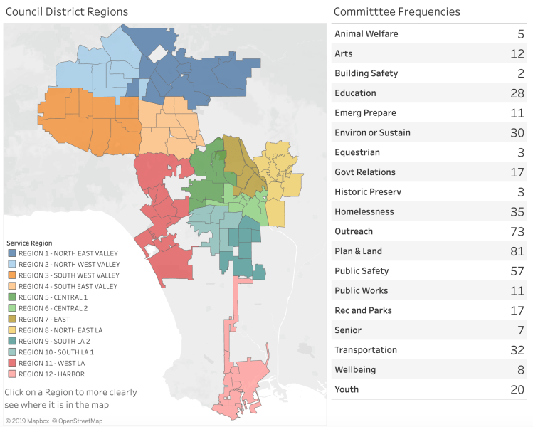
In a previous post on sustainability activity in Los Angeles Neighborhood Councils, I mentioned I had visited all the NC websites I could find to develop and inventory of the committees in each council. I compiled this in a table and published it online to Tableau in an interactive map and associated table.
Click on this image to be navigated to the Tableau website to explore the data more closely.
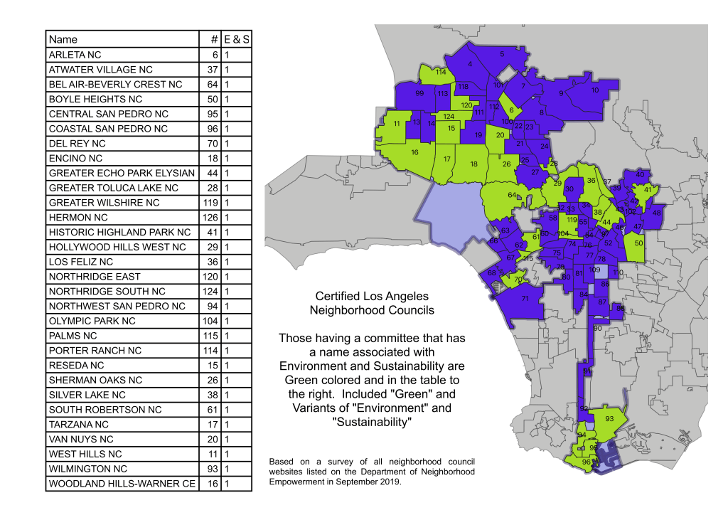
Prior to attending the Congress I was curious about which of the 99 Los Angeles Neighborhood Councils had committees with a focus on sustainability / environmental concerns. Starting with the websites listed on the Department of Neighborhood Empowerment’s council listing, I recorded the committees listed on each neighborhood council’s website. I was struck at the diversity of committees across the city (equestrian, historic preservation, wellbeing, arts, and emergency preparedness to name a few) but was focused on identifying those neighborhood councils that had a committee with some variant of “green”, “environment”, “sustainability” or “resilience”. While resilience generally has a different focus, I included that term as it suggests the neighborhood has concerns about the climate and the impact it will have on our lives. In all, I found that about 25 of the neighborhood councils had standing committees that seemed to have some level of activity.
I decided to map the 99 councils highlighting those with a sustainability committee to see where they were and whether there were any patterns. Sure enough, I see two clusters of NCs with sustainability committees: in the harbor area and in the valley.
Beyond the harbor and the valley, there are a few additional neighborhoods with sustainability committees: Echo Park, Silver Lake, Del Ray and Palms to name a few.
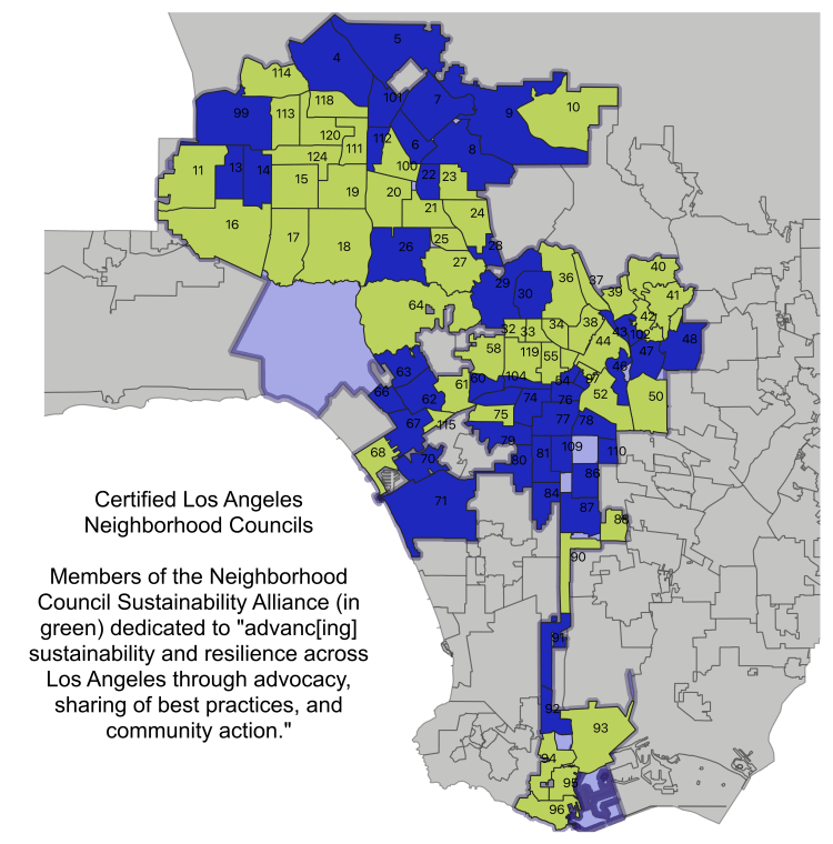
Having heard that there were 50 neighborhood councils represented on the NCSA I wanted to get a sense for whether those followed the same pattern and where the roughly 25 neighborhood councils were that did not appear to have a standing sustainability committee but were represented on the Alliance.
One can see that the pattern for the NCSA membership is a superset of those with a sustainability committee with an additional number of neighborhoods in the valley and then a few more to the East.
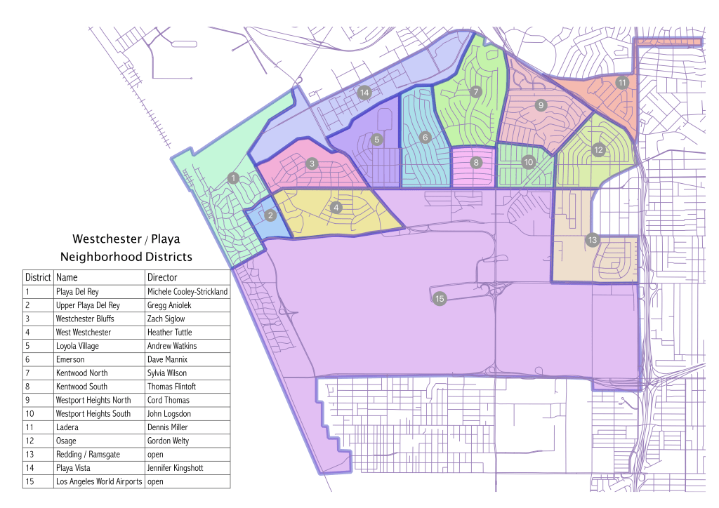
As I described in the About page of this blog, I am focused on analyzing data about living, school, work, worship and other aspects of life in Westchester / Playa with an emphasis on geospatial analysis. I thought I would start by introducing you to the 15 neighborhoods within the boundaries of the Neighborhood Council of Westchester / Playa.
First, let’s talk about the data. I found the boundaries of the 99 neighborhood councils of Los Angeles on the Los Angeles data portal but could not find a digital map laying out the neighborhoods within each council area. I decided to create my own. Using QGIS, I loaded the OpenStreetMaps street segments and used the map available at the Los Angeles Department of Neighborhood Empowerment (see Boundary Map on the right panel) to roughly digitize the boundaries of the 15 neighborhoods. I say roughly as I wanted to get something quick and dirty that would display well in a map well and could be used to do some initial spatial analysis with reasonable accuracy. I have loaded the data into my Google Drive data folder.
In my search I also could not find a map that displayed the common names of the 15 neighborhoods within Westchester/Playa so thought I would tackle that first. I took a first cut at identifying the names of the neighborhoods (if I recall, I knew 8 of them confidently) and then asked the relevant district directors what their neighborhoods were called in the October board meeting. I am not certain about the name for Redding/Ramsgate (anyone know better?) but otherwise this map shows the district numbers, names and the district director for each neighborhood.
Map of 15 neighborhoods of the Neighborhood Council of Westchester / Playa (as of October 2019).
Our neighborhood council was one of the first to become certified in 2002. Many of the board members have been on the board for over 10 years with some having sat since its certification. The recently retired eminent president, Cyndi Hench as president for 10 years. In the 2019 election, all odd seats were up for contest (as happens every 4 years). Of the 8 seats up for election, 5 ended up with fresh new faces (3, 5, 7, 9 and 11) while unfortunately 2 remain open (13 and 15). While a lot of really valuable institutional knowledge has left the board, we are fortunate that Pat Lyons, former committee chair for the Planning and Land Use Committee (and one of those founding board members I mentioned) has agreed to stay on the committee and Cyndi remains available for advice and guidance on how to run an effective neighborhood council. With our new leadership, we’re off to a great start.
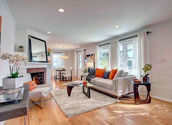
For my first post I thought I would tell you a little about myself and my experience in Westchester. My wife and I moved to Westchester in January 2016 after living for years in Santa Monica where we both worked. Living in a cozy apartment, we watched large residential units popping up throughout the City significantly altering its atmosphere and personality. We were eager to move to a residential neighborhood with a diverse culture, engaged residents and reasonable commute to work. After looking for over a year with our great agent Claire Lissone, we found Westchester and have felt increasingly fortunate since moving every day. We were fortunate enough to be able to find a single family residence that was move in ready. A beautiful house we’ve loved from the day we first set eyes on it.
A first look at our new living and dining room nicely staged in mid-century furniture.
Since moving in, we’ve added solar and converted our gas heater into a heat pump offering air conditioning and heating that is all electric. These are part of a broader theme of mine to try to do our part to tackle increasingly extreme weather conditions.
In our search for a new home, I resorted to my early career in geographic information systems (GIS) and developed various maps of the communities surrounding Santa Monica looking at real estate costs, commuting times, crime and safety, access to services and more. Rekindling my excitement for performing geospatial analysis, I found the tools available today have improved remarkably over what was available when I first began. The primary tools in my chest today are an open source GIS desktop software called QGIS and the nimble programming language, Python.
After living in Westchester for a few years I noticed an increase in burglaries in the blocks neighboring our home. I found the Los Angeles crime data mapping website and started tracking these burglaries and found that 6 in a row happened to homes that immediately abutted active or recent construction sites. The website is useful but I thought we could have more meaningful understanding of the patterns and trends with more data. Through a circuitous route, I was introduced to Pat Karasick, the volunteer coordinator for the LAPD (volunteering is a great opportunity for retirees or anyone with free time in their schedule – the department needs all the help they can get). I proposed to her that I’d like to work with the team that does the GIS work in the department. I thought that with additional data one could try to develop predictive models of criminal patterns and behavior to help inform where the very constrained patrol officers should focus their efforts. Unfortunately I learned 2 things: I didn’t have the time to offer the commitment needed during the workday but more problematic was that even in working with the detectives, I could not get access to any more of the data.
The upside of this experience is that I met several people who eventually steered me to the Neighborhood Council where I wanted to engage in public safety but also became interested in planning and land use. I started attending Planning and Land Use Committee (PLUC) meetings in 2018 where I became more broadly intrigued by the council. Thanks to encouragement by my neighbor, Kimberly Fox, I ran for the District 9 residential district director seat on the board and was elected unanimously in June 2019. Okay, so I ran unopposed, but at least 250 people checked the box next to my name which felt encouraging. So, here I am, a board member on the neighborhood council and sitting on the Outreach, Public Safety and Government Affairs committees where I am learning the ropes working with incredibly selfless people giving service to our community.
Check back in periodically or sign up for an email to be kept up to date with my explorations in data.