As I described in the About page of this blog, I am focused on analyzing data about living, school, work, worship and other aspects of life in Westchester / Playa with an emphasis on geospatial analysis. I thought I would start by introducing you to the 15 neighborhoods within the boundaries of the Neighborhood Council of Westchester / Playa.
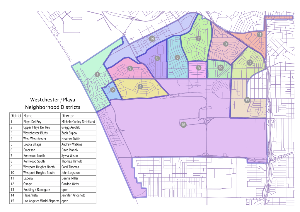
First, let’s talk about the data. I found the boundaries of the 99 neighborhood councils of Los Angeles on the Los Angeles data portal but could not find a digital map laying out the neighborhoods within each council area. I decided to create my own. Using QGIS, I loaded the OpenStreetMaps street segments and used the map available at the Los Angeles Department of Neighborhood Empowerment (see Boundary Map on the right panel) to roughly digitize the boundaries of the 15 neighborhoods. I say roughly as I wanted to get something quick and dirty that would display well in a map well and could be used to do some initial spatial analysis with reasonable accuracy. I have loaded the data into my Google Drive data folder.
In my search I also could not find a map that displayed the common names of the 15 neighborhoods within Westchester/Playa so thought I would tackle that first. I took a first cut at identifying the names of the neighborhoods (if I recall, I knew 8 of them confidently) and then asked the relevant district directors what their neighborhoods were called in the October board meeting. I am not certain about the name for Redding/Ramsgate (anyone know better?) but otherwise this map shows the district numbers, names and the district director for each neighborhood.
Our neighborhood council was one of the first to become certified in 2002. Many of the board members have been on the board for over 10 years with some having sat since its certification. The recently retired eminent president, Cyndi Hench as president for 10 years. In the 2019 election, all odd seats were up for contest (as happens every 4 years). Of the 8 seats up for election, 5 ended up with fresh new faces (3, 5, 7, 9 and 11) while unfortunately 2 remain open (13 and 15). While a lot of really valuable institutional knowledge has left the board, we are fortunate that Pat Lyons, former committee chair for the Planning and Land Use Committee (and one of those founding board members I mentioned) has agreed to stay on the committee and Cyndi remains available for advice and guidance on how to run an effective neighborhood council. With our new leadership, we’re off to a great start.
